Posts Tagged ‘Spokane region’

Spokane Smoke — not a hockey team

September 12, 2020

I feel bad complaining about our regional smoke regime. Others (hi, Portland) have it much worse. Still, this is more personal. As of Saturday evening, our AQI is 468 (UPDATE: we peaked Saturday afternoon at 523), which is the Hazardous+ range and is the worst in Washington. The good news is that the smoke has kept the outside about ten degrees cooler than forecast. Looking out our windows, it looks like a misty NW morning, but your lungs won’t agree.

Here’s our current status, and a forecast:

Even with the house closed up (and the windows locked, to tighten the seal) we can still smell the smoke. I’ve turned on our filterizing box fan and added a couple of humidifiers. I don’t know if the humidifiers will help, but the theory is that the mist will soak up the smoke and let it drift to the floor. Closing the door between the dog room and the rest of the house helped a lot. The dogs don’t stay there, it’s just an airlock to the outside world. We also taped a plastic garbage bag over the vent for the whole house fan. The fan isn’t running, but the seal is bad enough that smoke can seep through. Not very pretty, but it only has to last another 48 hours…or maybe 48 days.

Our bedroom has a room fan with a new HEPA filter, and it is working very well. Well enough that the smoke really hits you when you walk out to the rest of the house.

The good news is that, because of Covid, pretty much everyone in the NW has a stack of masks at home, suitable for indoor (or outdoor) wear.

Smoke gets in your eyes

August 4, 2017

I am always amazed at how far smoke can travel. Lots of fires up in British Columbia, lots of BC smoke in the Spokane area. Right now our AQI is 193. In Beijing, it’s 45.


Judging from the map, it will only get worse here. Out on our back deck, it takes the form of a light haze. You can smell the smoke, and your eyes water. I guess we keep the house closed up tonight.

UPDATE: Was still too smoky to open up, even at 11PM. 3/4 moon was a nice bright orange. I’d write a haiku, but I can’t think of a rhyme.

WA Smokes

August 25, 2015

Our AQI continues to seesaw up and down. On Sunday and Monday it peaked in the 165 range. Today it was only in the 150’s, and tonight it’s down around 90.  Here’s the latest AQI maps and forecast. The AQI Loop is the most useful.

Slow improvement today

Slow improvement today

Sunday night we had a deep red-orange demon moon. Monday it was our familiar silver quarter. And tonight, it’s barely showing through the clouds.

UPDATE: And here’s the WSU AIRPACT-4 smoke forecast.

WA Smokes

August 22, 2015

Not drugs. The wildfires along the east slope of the Cascades have been dumping smoke over to our side of the state. Here’s a MODIS shot from yesterday (21 August).

Red areas are active fires

Red areas are infra-red detected active fires


On the ground. Driving into Spokane, this is what it looked like:

WSDoTRraffiCam21Aug2015

Looking NorthEast

Eighteen hours later we were all clear, but you could still smell the smoke.

WSDoTRraffiCam22Aug2016

Looking SouthWest

Pretty much kept all the attendees at WorldCon 2015 inside.

T-Storms in the NENW

July 23, 2014

First big thunderstorm of the season just blew through the Spokane area at high speed. NWS says it moved at 50mph and I can believe it. Knocked over a tomato plant, and knocked out power for two and a half hours, a relatively rare occurrence. Not much rain, but not much lightning, either, which I’m sure makes the fire guys happy. In related matters, the Watermelon Hill fire was declared 100% contained earlier today, and the fire camp at the highschool has already broken up.

The Nest fire detectors came back on line immediately. The thermostats took a good half hour of “Can’t find network”.

A Fire in the NENW: 8AM Update

July 20, 2014

KHQ Channel 6 finally has a map up — and they’re the only one as far as I know. Here it is:

The pink means something to do with fire

The pink means something to do with fire

The map doesn’t have a legend, and isn’t even mentioned in the accompanying article, but it’s probably the active fire area.

Here’s a better map, of MODIS hot spot detections over the last 24hrs:

MODIS satellite hot spots

MODIS satellite hot spots
(h/t to Twitter user @509freckles for pointing this out)

The evac orders have been lifted for everywhere except the Fishtrap Resort (roughly at the second C in Hog Canyon Creek in the KHQ map). Since the winds right now are W and WSW it looks like it won’t be a threat (the campground symbol in the upper right corner marks the edge of Cheney), so I’ll stop pestering the Interwebs with reportage.

A Fire in the NENW: 7AM Update

July 20, 2014

Got up this morning to the smell of smoke in the house. I’d made the mistake of leaving the windows open, to cool us down. Now the place smells like we’ve been frying smoky brats.

Sky to the S and SW is normal, but there’s a smell of smoke in the air and I can see a smoky haze drifting amongst the houses and the trees, as if it were winter and everyone was firing up their wood stoves. The fire operations center is still manned and active. Trucks have been moved to the back of the HS parking lot, and the front lot filled with personal vehicles and official SUVs. Didn’t get down to the middle school to see how many people the evacuation effected. Heard a train. First one since the fire started (normally they come through every hour or so). The two rail lines run through the fire area, but I don’t know if it was a through train or stuff being moved from the Cheney rail classification yard.

Morning news doesn’t have much news, and Twitter is mostly complaining about that. The 7AM on-scene report didn’t tell us anything we didn’t know last night. Fire is still zero percent contained. Twitter says evacuees might be allowed home, depending on winds. Presumably because that area is pretty well burned over. Still no report on where the fire lines are. Do none of the newsies have a helicopter they could use? Can no-one just ask the fire operations center? Presumably it’s up in the Turnbull somewhere. Based on the evacuation boundaries, it’s in the vicinity of Alkali Lake. If the wind holds at WSW, as forecast, it will miss us to the south.

Winds remain low right now, but will pick up to last night’s level this afternoon. How bad were the winds last night? This bad:

Twenty pound tomato planter blown off the corner of the deck railing.

Twenty pound tomato planter blown off the corner of the deck railing.

AQI in Spokane is 156 = just in the Unhealthy range.

A Fire in the NENW

July 19, 2014

MJ and I were out taking our evening constitutional, in 80F weather and 20kt winds, when we noticed a largish pyrocumulus to our southwest.

Watermelon Hill

Watermelon Hill

We continued, arguing about if it was local, or just more smoke from the western fires. We got a little more interested when we saw what looked like a firefighting command post set up in the parking lot of the local high school — multiple trucks (admin style, no pumpers), plus a couple of comms vans with their antennae up.

Got home, checked the news (online, the over the air reporting is deathly slow). It seems a fire had started near Fishtrap Lake about 3PM, and by 5pm had blown into a full scale emergency, burning 10K acres. The Fishtrap resort and rural areas SW of the Turnbull are under a Level 3 evacuation (mandatory), and Tyler township has a Level 2 evacuation (be prepared). Tyler is only ten miles from us, as the wind blows, but the evacuees are being sent to Cheney Middle School, a block from our house, so I guess we’re safe.

Most of the useful news is on Twitter, with the hashtag #WatermelonHill.

Fires in the West

July 18, 2014

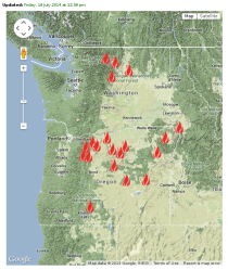
Our fire season is in full bloom. Northwest Interagency Coordination Center shows twenty major fires burning in Washington and Oregon.

Lots of fires, none near Spokane

Lots of fires, none near Spokane

The same strong westerly winds that are driving the fires are also pushing the smoke plumes into eastern Washington. Here’s a picture from yesterday (the current photo is obscured by non-fire clouds — or maybe darkness).

That's not valley fog

That’s not valley fog

As a result, we have some significant air quality problems here in the Spokane region

Orange means "Unhealthy for Sensitive Groups"

The Orange means “Unhealthy for Sensitive Groups”
The Orange is a lie


Now, the map says that Spokane is USG — Unhealthy for Sensitive Groups. That’s an AQI of 101-150. What was our AQI at 5PM? It was 148. So the map is a little misleading. Using standard Fuzzy Logic notation, one might say that Spokane has a 80% membership in the USG linguistic variable, and 20% membership in the Unhealthy linguistic variable.

The sky has been a sullen brown all day. The smell of smoke is sometimes strong. MJ says it reminds her of her childhood in Richland, just before a major dust storm. For me, it harks back to my days in Korea, when the sky would turn yellow in the Spring, as much of the Gobi Desert got carried east towards Japan.

In any event, no jogging tonight.